


adicionar à lista de desejos
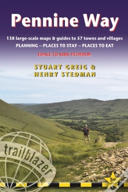
Pennine Way
Edale To Kirk Yetholm: Route Guide With Planning, Places To Stay, Places To Eat, 138 Large-Scale Maps & Guides To 57 Towns And Villages
idioma: inglês
Editor:
TRAILBLAZER PUBLICATIONS, Janeiro de 2019 ‧
ver detalhes do produto
ESGOTADO OU NÃO DISPONÍVEL
Venda o seu livro
SINOPSE
All-in-one, hiking route guide to the 256-mile Pennine Way, Britain's best-known National Trail. 138 large-scale maps (3 1/8 inches to 1 mile); full details of all accommodations, restaurants, pubs with reviews, plus public transport.
DETALHES
| Propriedade | Descrição |
|---|---|
| ISBN: | 9781912716029 |
| Editor: | TRAILBLAZER PUBLICATIONS |
| Data de Lançamento: | Janeiro de 2019 |
| Idioma: | Inglês |
| Dimensões: | 120 x 180 x 17 mm |
| Encadernação: | Capa mole |
| Páginas: | 312 |
| Tipo de produto: | Livro |
| Coleção: | Trailblazer British Walking Guides |
| Classificação Temática: |
Livros em Inglês
>
Guias Turísticos e Mapas
>
Outros Guias
|
| EAN: | 9781912716029 |
LIVROS DA MESMA COLEÇÃO
-
10%Whizzy Wheels Camper VanGARDNERS OB6,75€ 10% CARTÃO
-
10%10 Playful PrincessesGARDNERS OB6,75€ 10% CARTÃO