


adicionar à lista de desejos
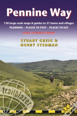
Pennine Way
Edale To Kirk Yetholm: Route Guide With Planning, Places To Stay, Places To Eat, 138 Large-Scale Maps & Guides To 57 Towns And Villages
language: english
Publisher:
TRAILBLAZER PUBLICATIONS, January of 2019 ‧
see product details
OUT OF STOCK OR NOT AVAILABLE
Sell your book
SYNOPSIS
All-in-one, hiking route guide to the 256-mile Pennine Way, Britain's best-known National Trail. 138 large-scale maps (3 1/8 inches to 1 mile); full details of all accommodations, restaurants, pubs with reviews, plus public transport.
DETAILS
| Property | Description |
|---|---|
| ISBN: | 9781912716029 |
| Publisher: | TRAILBLAZER PUBLICATIONS |
| Release Date: | January of 2019 |
| Language: | English |
| Dimensions: | 120 x 180 x 17 mm |
| Cover: | Softcover |
| Pages: | 312 |
| Format: | Book |
| Collection: | Trailblazer British Walking Guides |
| Categories: |
Books in English
>
Tourist Guides and Maps
>
Other Guides
|
| EAN: | 9781912716029 |
BOOKS FROM THE SAME COLLECTION
-
10%Whizzy Wheels Camper VanGARDNERS OB6,75€ 10% CARD
-
10%10 Playful PrincessesGARDNERS OB6,75€ 10% CARD